Empty Pipes
Largest Ski Areas On Each Continent
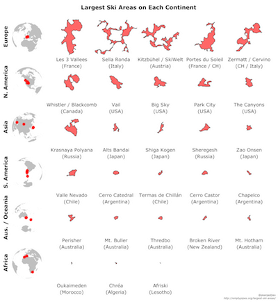
The chart below shows the five largest ski areas on each continent (except Antarctica). Africa only has three entries because those are the only ski areas I found with annotated ski lifts and slopes. Everything is calculated according to some reasonable yet arbitrary heuristics so please take the rankings with a grain of salt. If you click on a ski area, it will be displayed in the map below.
The Map
All the ski areas in the chart above are annotated on the map below. Clicking on an area above centers the map below.
How it’s made
Each ski area is defined by something like an alpha shape, calculated over all the lifts and slopes. Each “alpha shape” -like area is calculated by first creating a Delaunay triangulation of all ski lift and slope waypoints. Every triangle which has a side greater than 1km is then removed. The result is a set of disconnected shapes all composed of multiple triangles. Each aggregation of triangles is what I consider a ski area.
In some cases, this can lead to two ski resorts being connected even though you might have to walk up to 1km to get from one lift to another (e.g. Kitzbühel / SkiWelt above). In the opposite case (e.g. Oukaimeden), a long lift may not be counted simply because the points defining it create degenerate triangles. Nevertheless, in most cases the shapes created reflect the ski areas they represent quite well.
Here’s the recipe to re-create the graphic:
- Download OpenStreetMap dumps of each continent
- Filter for lifts and slopes
- Sample points along long segments to make sure they’re not split
- Calculate a Delaunay triangulation of all the OSM nodes and the sampled points
- Exclude all triangles which have an edge longer than 1km (concave hull of sorts)
- Polygonize
- Google the towns near the resorts to figure out what the resorts are called
- Convert to topojson and downsample to reduce the size
- Make table using d3.js
- Create zoomable map using leaflet.js and a d3.js overlay
Questions? Comments? Twitter (@pkerpedjiev) or email (see about page).